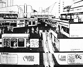
The Car Becomes King
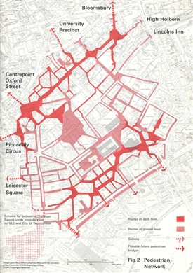
1971 plan, pedestrian routes
Covent Garden Community Assocation
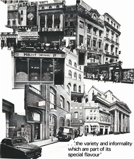
1968 Montage of the plan
Covent Garden Community Assocation
Scheme to connect Covent Garden with Piccadilly
Covent Garden Community Assocation
The government finally agreed to take control of the market in 1961, and the Covent Garden Market Authority was established in 1962. It purchased the site for £4 million, or about £300,000 per acre. Plans were immediately revived to move wholesale fruit, vegetable and flower trading out of the centre of London. The authorities saw that, once the market vacated its 14 acres, there would be an opportunity to redevelop an area 5 times the size. Much of the built environment was run down, and leases were expiring. So in 1965 a consortium was created to oversee a massive development plan, comprising the Greater London Council (GLC), Westminster and Camden councils.
Plans were busily drafted over the next 3 years. Businesses and property developers were invited to contribute from the earliest stages … but nobody asked local people what they thought.
At that time urban planning theory was keen to distance traffic from people, so a major road system without pavements was planned to sweep around the centre of Covent Garden. A 4-lane ring road would be driven through the 18th and 19th century streets:
- To the south, it would remove the fabric along Maiden Lane, Henrietta Street and Tavistock Street.
- To the east, property was earmarked for clearance to push a new road between Drury Lane and Kingsway.
- To the north, the roadway would flatten Macklin Street and plough through Shorts Gardens, the centre of Seven Dials, and Earlham Street.
- Demolition would take place in a swathe to the West to widen Charing Cross road, or to build a new road between Charing Cross Road and St. Martin’s Lane.
This was the era of the Elephant & Castle redevelopment, the Barbican Centre, the new Euston Station, and inner ring roads. Covent Garden, and indeed much of the West End, faced the same fate.
The ‘Covent Garden Area Draft Plan’ was printed up in 1968, with an exhibition attended mainly by those with commercial or political interests; very few local people knew that it was taking place. A 118 page document rhapsodised about the charm of the area, with its old family businesses, ‘special flavour’ and unique features. It detailed ‘a surprisingly large number of buildings of real merit and interest’ and ‘a long and distinctive history still subtly expressed in its present character’.
Yet the same plan showed how two thirds of Covent Garden would be demolished to make way for what outsiders thought should be done. Land values soared to over £1 million per acre.